Saturday, October 31, 2009

Process: Google Sladdakavring


Been thinking of how to represent the Tongue Rug. Experimenting. Though it is decidedly ugly, if I flip the Google map upside down, the waypoints do look like some sort of makeshift sladdakavring.


Yet if I isolate the pattern, it does makes an interesting grouping albeit, spread out. Not sufficiently rug-like. More viral.


I’ve noticed that other tongue rugs are being created online. Individual tongues (blog postings) are starting to show up in search engines because of the tags. Dependent on the search criteria, the user has the potential to create their own Tongue Rug outside of my blog. I like the chance element in this process.

There is also another sort of tongue rug that is emerging, a pseudo tongue rug based on misleading tags. These “fake” sites dynamically load content into their pages by crawling the web for tags from blogs and YouTube. A sampling:

  • bestof vidéos de A à Z
  • cascapedia videos | TheGolfTv.com
  • Magdalene videos - Online Adult Dating Free
  • Whitefish, Ontario videos on TripAtlas.com
  • Fireball Planet Free Videos Online - Top Videos - All Free Videos
  • Gegevens van Julie – Wieowie
  • Bonaventure - Cafe.hr
  • laurentides videos - Global Videos
  • Hybrid Cars - Hybrid Vehicles

Were it a person creating these sites, they would realize right away that the content does not match. As the machine cannot make the differentiation, the Tongue Rug videos are popping up in unrelated sites through a mash-up process — like Tzara’s paper bag poem. I find it amusing that a user visiting the dating site, or an avid golfer, will be puzzled by these videos of slow-moving landscapes. Will they try and make a connection? Will they investigate further or just shrug it off? I like the surprise element in the process.

So there are several Tongue Rugs in this project separate from my own experiments — the search engine rug, the mash-up rug. Rugs that grow of their own accord. A disquieting process as well as I have no control on which sites my “tongues” could potentially end up.


Sunday, October 25, 2009

Process: Lac aux Loutres


Went to the Théâtre Corona in Saint-Henri on Sunday to join in on the celebrations for the 25th anniversary of RESO (Regroupement économique et social du Sud-Ouest). L’autre Montréal started off the all-day event with a bus tour of the Sud-Ouest. I’ve always appreciated their extremely well-researched tours; generously animated by Bernard Vallée, this circuit was no exception.

First stop was the Georges-Vanier building in La Petite Bourgogne, site of the first francophone public library in Canada when Saint-Cunégonde was annexed into the city of Montréal in 1906. Highlights was learning about the beautiful old buildings converted into artist spaces: L’Espace Verre in what was once Fire Station no. 21 in Victoriatown, and Quartier Ephémere in the Fonderie Darling building close to Griffintown, one the oldest working class neighbourhoods in Canada. We also visited the site of a new urban project, La cité des artistes, which will be situated in Les Bassins du Nouveau Havre on the north berg of the Lachine canal. The four original St-Gabriel Basins – which were built between 1848 and 1885 – will be excavated as part of the new development. The proposed plan also includes living/working spaces for artists, rental spaces for art and community organizations, as well as housing for families.


With all of the debate over the Turcot interchange reconstruction project and the threat of expropriations in St-Henri's Village des Tanneries, it was sobering to go through what used to be Victoriatown. This community, also known as Goose Village, was razed down in 1964 in preparation for Expo 67. All that is left now is what is called the Black Rock, a memorial to the thousands of Irish immigrants who succumbed to typhus in the 1840s. In Griffintown, we passed the site of St. Ann's Catholic Church, torn down in 1970, and the stable which houses the Old Port’s calèche horses – symbol of another era. In Pointe Saint-Charles, the seigniorial era is recalled by its toponymy. In 1663, the Sulpicien priests were granted land in the Pointe which is why the area used to be called ferme Saint-Gabriel or ferme des sulpiciens. At the end of the 1860s, much of the agricultural land had been parceled off in response to the rising industrialism along the Lachine canal and the development of the Grand Tronc rail yard. All that is left is a road sign – Rue de la Ferme.

It reminded me of my Gaspésie trip when I arrived to a point where I thought there was going to be a village called La Ferme, but did not see any dwellings. Perhaps a name on a map was all that was left of a small farming community? Here in Montreal, I wonder if the rue Angers in Ville-Émard, which runs from St-Patrick canal-side to a grove of old trees in a park, refers to Angers in France or simply indicates that it used to be an old farming road?

The overall sense that I gleamed from the tour is that the Sud-Ouest is lacking in monuments that reference its rich history since so many cultural and architectural landmarks have been lost. Bernard Vallée did mention some recent efforts like the official signage in parks which explain the site's history and public figures. I wonder if some of this memorialization is also taking place online, in an unofficial way? On a grassroots, collaborative level, rather than on a grand, monumental scale? The associative nature of the Web, its palimpsest quality, makes it the ideal tool to document layered narratives through time as evidenced by the many blogs on the subject of history, architecture and urban planning. I found this richly detailed blog by Andrew Emond that documents hidden waterways in Montreal by way of an interactive map quite interesting. Another blog of note is Walking Turcot Yards where I first came across a ghost lake back in 2007 – Lac aux Loutres.


Working on my pathmap the last couple of weeks, I decided to deviate from my initial list of lakes with the Lapalme-Legault-Angerbauer placenames. Much like I integrated Lac-à-l'Épaule into my pathmap by its association with George-Émiles Lapalme, I will also include Lac aux Loutres. The architectural firm Béïque, Legault, Thuault has proposed the Lac à la loutre project with the aim to transform the zone between the Saint-Pierre and Turcot interchange into a thematic parc. At the heart of the project is the restoration of the ancient Lac aux Loutres. This wetlands was once the bulging part of the Rivière Saint-Pierre – the precursor to the Lachine canal. The canal now follows Rivière Saint-Pierre's course and Otter Lake is embedded somewhere underneath the Turcot rail yards, having been filled in during the 19th century.

As this ghost lake is in my immediate vicinity, it is fitting to add it to the pathmap. This lost lake that has changed through time is also in line with the Tongue Rug project’s focus on the mutability of shifting placenames, maps and even geographical features through time.

Saturday, October 24, 2009

Progress: October 23, 2009


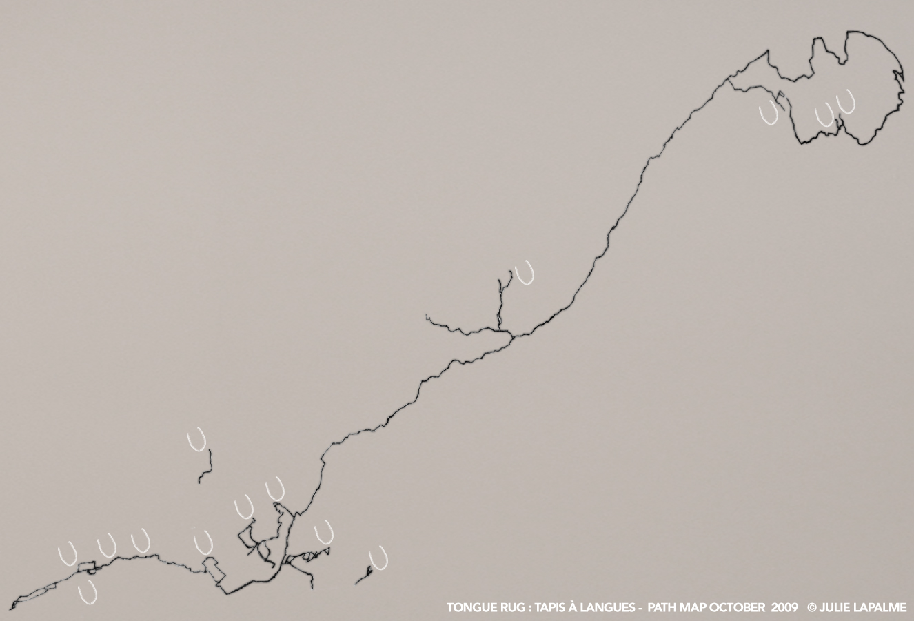
Though online apps (Bikely and Google Maps) do give me a general view of the paths I’ve been tracing over the years, I wanted a more complete picture. I had been treating the paths too piecemeal, needed to map them out to see the whole tracing. Took the Quebec road atlas that I had used to plan my bike trips, and photocopied a slew of pages. It was a pain to piece them together as the legend was different on certain pages — the Gaspésie tip is not quite to scale with the rest of the map. Also, it was hard to be precise as some pages did not align properly despite my efforts. Nonetheless, it was a satisfying exercise sitting on the floor cutting and taping together this growing map, page by page. To my surprise, I was left with a ten-foot long scroll of paper. Had to affix it to the living room wall to be able to see it in its entirety.


I crafted some ad hoc tongue-labels to mark out the waypoints and highlighted the paths. Stepping back I was a little shocked to see that I had traveled all that distance. The map was a visual manifestation of my moving through space, but also the time spent reaching each waypoint. It sounds silly to say, but I find it amazing how the human brain can look at a squiggly line on a map,  and this abstract symbol can trigger memories, sensations and inner pictures about having been in that space — in the flesh. That tension between the conceptual and the physical.

The paths themselves were intriguing as well. Their varied shapes were of course dependent on the terrain, but they were also testament to my lack of experience in the beginning of the project. LE-3 starts from Ste-Agathe des Monts and is not attached to the network as I had received a ride up to the Laurentians and rented a bike from the campground. I had not yet attempted long solo cycling trips. Also, A-9 is full of loops and backtracking as I was lost for most of the day, not properly focusing because I was cycling with a friend.


I’ve been making vector paths according to the topographical maps, but the precision makes it very time consuming. Went low tech: took a photograph of the wall and isolated the path in Photoshop. I wanted a quick overview of the pathmap.

In the beginning, the paths did not touch, but over the years, they did create a network — a tracing that largely follows the St-Laurent and the Outaouais river. I was pleased with how the crisscrossing lines looked like discarded thread. The tracing was random in the sense that I was cycling to the bodies of water with one of my family names that were nearest to me, by whatever path which facilitated my travels, further complicated by my admittedly inconsistent orientating skills.


Put some tongue markings as well — a little breast-like but no matter — to get a sense of the tongue rug progress. I don’t get a sense of the sladdakavring yet, as the waypoints are too spread out. I will experiment with other renderings.

Monday, October 19, 2009

Process: Gabrielle in la Gaspésie


Saint-Tharcisius

Went to a public reading of Le temps qui m’a manqué by Gabrielle Roy at the Maison de la Culture Marie-Uguay. Published posthumously in 1997, it was intended to be the third section of her autobiography La détresse et l’enchantement.

Hearing her words spoken out loud by Marie-Thérèse Fortin was quite moving; in fact, the next day I went to the library to find the book so that I could read it on the train on my habitual Montreal-Ottawa commute. Quite fitting as the book mostly takes place on a journey. Memories resurface for the author brought on by the rhythmic nature of the train moving on the rails. She loses track of where she is as well as the time such that she is lost in her thoughts and emotions, rememorating her mother who had recently passed away.

Often while on my bike trips in search of my lakes, I’ve experienced that same sensation: at times in the moment (feeling the sun on my back, sweating or forcing my muscles), and at other times, absent, miles away in my thoughts brought on suddenly by a colour, a shape, or a smell.

I could relate to much of what Gabrielle Roy wrote about in this particular work, not so much as a fellow author — though the writing process does feature in my art practice, it is more of a tool to elucidate my ideas in my working process — but as an artist. The paragraphs where she described her creative process were the ones that resonated for me. I understood her need to search for a room of her own where she could write.

As a Franco-Ontarian, I was equally moved by the excitement she felt in discovering Québec, as an outsider in sorts hailing from Manitoba. I understood her desire to visit L’Assomption where her mother once had lived, the urge to reconnect with her roots.

She described her longing for a quiet place to write, but she did not seek out extreme solitude as she would make herself a “makeshift” family in her many refuges: her room in Rawdon in the Laurentians, her room at Miss Maclean’s house on rue Dorchester, and her much sought after room with the McKenzies in Port-Daniel.

This section where she recounts her train journey to the Matapédia Valley is riveting; the sense of traveling to the unknown, to find something one is searching for without yet knowing what it is. At the sight of a house on the hill in Port-Daniel, she disembarked from the train and negotiated to secure the best room in the house — prized for its view of the water.

While on my Gaspésie bike trip, I experienced a similar feeling. In search of my waypoint in Saint-Tharcisius, I cycled in circles through bright green fields and sparsely forested areas. I eventually found what remained of Angers bridge/pont Angers (A-10) – soft and shredded pieces of rotten wood embedded in the middle of a pathway in a field.


View Panorama
A-10 Angers Bridge / Pont Angers
July 7, 2003


While taking photographs in the round, I noticed the path lead to a little white house with a red roofed barn beside it with the bluish Monts Notre-Dame in the distance. A simple pastoral scene that struck me by its sheer beauty. I had to fight the urge to follow the path right up to the house and knock on the door. I could appreciate how the tranquility of the surroundings could help bring forth creative pursuits.

I could fully understand the happiness and relief in finding a room where she could deliver herself to her need to write — that feverish production period where all is heightened and the usual daily routines pass by the wayside or are done with haste (eating, drinking, washing, social events). The important thing is to not interrupt the flow, to keep at it while alight with all that buzzing.

She describes spending a night out in the storm by the water, shivering and feverish. These high emotions must have been due in part to the full consciousness of knowing that she was doing exactly what she was meant to be doing.

I was surprised to discover that Gabrielle only managed to work on Bonheur d’Occasion three times a year, when on breaks from her job. It subsequently took her three years to write the novel. How many times have I had to put my Tongue Rug project on the shelf because of pressing deadlines at work or my thesis?

Planning a train trip this summer to visit a friend in Winnipeg; 375 rue Deschambault will definitely be a stop-over.

Friday, September 18, 2009

Sunday, September 13, 2009

Progress: September 13, 2009


Uploaded the latest panorama to YouTube ( LA-3 ), probably the last one for this year. Making the Google map, it was satisfying to see my progress in a visual manner. The remaining waypoints will have to wait for warmer weather as they are remote and it would be unsafe to travel alone because of the bears. Berries were late this year due to the rainy summer; there has been more human-bear contact in the news lately. Many will die this winter because they did not fatten up enough to survive the long hibernation.

Yet, others can help me document the waypoints for my sladdakavring. Users can share their stories each placename as each tongue has a form so that they can submit their own story. I've heard about Lake Lapalme ( LA-1 ) in the Laurentians before setting foot in that area by reading about another's experience.


View Tongue Rug Status in a larger map


Legend: Blue = documented Red = undocumented Bold = documented

  • 021M Baie-Saint-Paul (1:250000)
    • 021M12 Lac St-Henri (1:50000) ( LA-5 LE-4 )
  • 022A Gaspé (1:250000)
    • 022A15 Sunny-Bank (1:50000) ( A-11 A-13 )
  • 022B Matane (1:250000)
    • 022B08 Rivière Angers (1:50000) ( A-11 )
    • 022B11 St-Jean-Baptiste-Vianney (1:50000) ( A-10 )
  • 022C Rimouski (1:250000)
    • 022C14 Lac Cassette (1:50000) ( A-8 )
  • 022D Chicoutimi (1:250000)
    • 022D03 Rivière Pikauba (1:50000) ( A-6 )
  • 022E Réservoir Pipmuacan (1:250000)
    • 022E09 Lac Gouin (1:50000) ( LE-5 )
  • 022F Baie-Comeau (1:250000)
    • 022F06 Lac Le Barbier (1:50000) ( LA-2 )
  • 031G Ottawa (1:250000)
    • 031G09 Lachute (1:50000) ( LE-9 )
    • 031G10 Hawkesbury (1:50000) ( LE-6 )
    • 031G11 Thurso (1:50000) ( LE-1 LE-8 LE-10 )
  • 031H Montréal (1:250000)
    • 031H07 Granby (1:50000) ( LA-6 )
    • 031H11 Beloeil (1:50000) ( A-9 )
    • 031H12 Laval (1:50000) ( MO-1 )
    • 031H13 Laurentides (1:50000) ( LA-3 LA-4 )
  • 031J Mont-Laurier (1:250000)
    • 031J01 Sainte-Agathe-Des-Monts (1:50000) ( LE-3 )
    • 031J11 Ferme-Neuve (1:50000) ( LE-11 )
    • 031J14 Sainte-Anne-Du-Lac (1:50000) ( LE-7 )
    • 031J15 Lac de la Maison de Pierre (1:50000) ( LA-1 )
  • 032C Senneterre (1:250000)
    • 032C05 Barraute (1:50000) ( A-12 )
  • 032D Rouyn-Noranda (1:250000)
    • 032D14 La Sarre (1:50000) ( LE-2 A-7 )
  • 033B Lac Lichteneger (1:250000)
    • 033B02 Gorge Prosper (1:50000) ( A-4 A-5 )
  • 041I Sudbury (1:50000)
    • 041I03 Lake Panache (1:50000) ( PA-1 )
  • 073E Vermilion (1:250000)
    • 073E06 Mannville (1:50000) ( A-1 )
  • 082G Fernie (1:250000)
    • 082G01 Sage Creek (1:50000) ( A-2 A-3 )

Part of me is curious about the body of water itself and the details surrounding its placename, and the other part of me is conscious of the path I am tracing with my passage. I will concentrate on the writing aspect of this project for now.

However, I am starting to think about more concrete manifestations of my ideas. I like that the tongue rug will remain virtual through the blog postings, but I also envision a sculptural series based on the sladdakavring, the threads (path tracings) as well as the lakes themselves. Of course, like with Orphan Train - Trained Tales, these 3-D objects will eventually be integrated into the web aspect of the project. I'm just at that stage where I need to work with my hands. Also, I like exhibiting my online work with sculptural elements.

Saturday, September 5, 2009

Path: LA-3


YouTube  l  Panorama
LA-3 Lapalme Waterway / Cours d'eau Lapalme
September 6, 2009


Day 1 – September 5, 2009

My waypoint (LA-3) was only 50 km away  — as the crow flies  — according to my GPS. Instead of taking a northern route, I decided to go east and stay overnight in L’Assomption. The next morning I would have time to find the waypoint and return to Montreal via Laval. I had passed through L’Assomption while doing the Chemin du Roy on my LA-5, LE-4 trip. The Route Verte often bypasses cyclists away from traffic on the main strip and into the suburbs, but then you don’t get a sense of the town. I wanted to explore further.

It was a crisp, sunny Fall morning, but with headwind. Very few cyclists on the roads. I took the cycling trail on Notre-Dame to get off the island but avoided the pock-marked-labyrinth-like cycling trails through the smaller streets and stuck to Notre-Dame and Sherbrooke as there was little traffic. Left before the GPS had tracked all the satellites so it was in searching mode for the first two and a half hours. The interface also had lines going across the screen. It may be on its last leg. I didn’t get a reading until I reached the intersection of 100e avenue and Sainte-Maria Goretti — the bridge crossing to Repentigny. Passed the Céline Dion globe in Charlemagne and immediately saw the Route Verte trail that I had completely overlooked the last time. It took me all the way to L’Assomption through fields, suburbs and industrial parks.

Pleasantly surprised to have arrived before noon, I ate and strolled around town to survey the local architecture. I am always drawn to humble structures: the tiny chapel always outshines the ostentatious basilica. Chapelle Bonsecours was covered in vines and harboured a small cemetery with a few weathered tombstones intermixed with new ones. I was glad to see a few stone houses with the characteristic metal low sloped roofs which date from the Ancien Régime. There were also fieldstone houses with their bulbous walls, dwellings which touch me as I admire the adaptability of the early settlers, merging traditional French methods of construction with the materials at hand.

I tried to visit the Thérèse-Beaudry garden but it was closed. The panel explained that it was an example of an 18th century garden with its combination of fine herbs (thyme, sage and chives) and topinambours, sureau and pimbine. I’ve always had trouble remembering the French equivalent to English plant names (as well as fish species and trees).  Had to look up certain terms after my trip. A topinambour is the Jerrusalem artichoke or sunflower, which made sense as the tuber is edible, while sureau is the elderberry bush, again an edible berry. Pimbine was not in my dictionary. Like the fieldstone houses, this functional garden was exemplary of the determination to survive in this new geography and climate. Thérèse Beaudry was the wife of a soldier from the LaSarre regiment. Married in 1760, she gave birth to 16 children before she died at the age of 35 years c.1778. She was pregnant for almost every married year of her short life. It was sobering to read about this woman. I know I sometimes take my freedom for granted. Almost 250 years later, my everyday reality is quite different. I travel alone in relative safety when at one time unmarried women were discouraged from venturing unaccompanied outside the home.

I came across a few explicative panels by the river.

Il sort des terres une autre petite riviere du costé du Nord, nommé des François la riviere de l’Assomption, et des Sauvages 8taragauesipi, laquelle se iette dans cette grande étendue d’eau qui se rencontre a la pointe plus basse de Montreal.Relations des Jésuites, 1642.

The Outaragavisipi placename, meaning “rivière tortueuse”, was fitting as the river is indeed winding, almost forming a figure 8. In fact, there was a popular First Nations portage spot where the land almost meets at the middle of the loop. Rivière de l’Achigan and Rivière Saint-Esprit, which feed into l’Assomption are even more twisting. The Lapalme waterway is an offshoot of the latter.

Though it was a short cycling day, my knees were sore. Headwind is tiring on the body. I had pulled my inner thigh muscle. Having tired of limped through town, I retreated to the B&B and its sun dappled rooftop terrace.


Day 2 – September 6, 2009

“Au postillon de l’Assomption” is a B&B in what used to be the town’s original post-office. The owner told me its history over breakfast. Before leaving I asked her if “postillon” was a diminutive term for post office. I didn’t realize that it meant the drop of saliva that is projected forward when speaking to someone. She added that the word used to refer to the person who drove the mail coach, a horse-drawn carriage. Lovely metaphor the "flying spit" as messenger, airborne gossip. I laughed to myself as I am aware of my limited vocabulary in French. Growing up in a largely Anglophone environment, I did not often hear French. A bookworm, most of my French vocabulary was acquired through the act of reading. As I would often try to approximate the meaning of unknown words, this led to confusion at times. For instance, when I first got to the B&B, the owner tried to show me how to unlock a fussy door latch. She told me I had to “trousser” the handle which was an unfamiliar verb to me. When I looked it up later, I saw that the verb was a familiar form of retrousser (to pull up) as in “trousser la jupe”. In a similar vein there was also a “trousseur de jupons” (un coureur de filles).


Once on the road, I cycled on quiet country lanes enjoying the cool breeze. Something hissed at me as I checked my map on a small road in the middle of two cornfields, the dry husks crackling in the wind. My GPS, an older model, does not have detailed maps. The rangs are often not displayed. All I see is the trace of my path on a blank screen. I use it mostly to lock in my waypoint and situate myself in relation to it. I have always had trouble with cardinal points, with determining left and right. My orienting style tends to rely on landmarks. It is hard not to notice the towering Croix de chemin that line the Chemin du Roy.

I backtracked all morning trying to find my waypoint, up one lane and down another. I passed right by my destination the first time. At a crossroads I checked my GPS to discover that LA-3 was situated about half a kilometre in the other direction. I turned back and cycled at a slower pace, scanning the fields. I knew from prior trips that unlike a river, a waterway is usually discreet and could possibly be dried up. I hadn’t seen another body of water apart from the serpentine Saint-Esprit. But at the base of a hill, in a shady grove of trees, I dismounted almost by instinct. I could just discern a rivelet of water in the weeds. It reminded me of the LE-10 waypoint, where I could only hear trickling in the bush with no water in sight. This location was more picturesque with its wild flowers and the surrounding fields with their regular rows swaying in the wind.


After taking my photos in the round, I started packing my things back into my bike panniers. A transport barrelled around the corner and down the small hill, its wheels spinning into the gravel where my bike had been initially placed. He most probably was going high speed on a straight stretch of road and didn’t anticipate this sudden slight dip. It had been calm, with little traffic and then with no warning, this thundering charge. I thought of the small white crosses decorated with flowers by the side of the road that I had passed in my travels. I shivered, certain that the driver had also had a fright.

I stopped to eat in Saint-Roch-de-l’Achigan. I asked if the crêpes were made with buckwheat flour. The waitress said no, that would be the “Galette de Sarrasin”, made from local flour. It looked like grey shoe leather but slathered with butter and thick brown molasses, it tasted incredible. Certainly gave me the energy needed for the long ride home.

The smaller roads were not always well marked so I was constantly altering my route. I also went the wrong way twice. In St-Vincent de Paul I couldn't resist following other cyclists going downhill until I realized that the bridge to Laval was nowhere in view. In Montreal North I couldn’t remember the street which took me all the way to Van Horne. So I passed Christophe-Colomb, only to backtrack once again after asking a fellow cyclist for directions. The trails were congested and it took longer than anticipated to get home. It was difficult to switch gears – the fast pace of a crowded city after the tranquility of country roads with wide open spaces.

Day 1 – September 5, 2009


Time Location Trip Odometer Moving Time Stopped Max Speed Moving Average
8:00 Arrive:
10:30
100e Ave/ Sainte-Maria Goretti
Apx. 40 km
GPS not working
       
  Céline Dion Globe, Charlemagne
N 45°43'071"
W 73°29'143"
         
Arrive:
11:30
L’Assomption
N 45°49'574"
W 73°25'40"
17.8 km + 40 = 58 km 1:02 + 2:30 = 3:30 8 min 42.1 k/h 17 k/h


Day 2 – September 6, 2009


Time Location Trip Odometer Moving Time Stopped Max Speed Moving Average
8:30
Arrive:
10:40
LA-3
N 45°53'833"
W 73°37'546"
33.5 km 1:48 20 min   18.5 k/h
Arrive:
11:50
Saint-Roch-de-l’Achigan
N 45°51'393"
W 73°35'310"
43.9 km 2:22 30 min    
Arrive:
2:10
Terrebonne Bridge to Laval 76.1 km 4:08 51 min   18.3 k/h
Arrive:
3:15
St-Vincent de Paul (backtracked) 93.5 km 5:04 1:03    
Arrive:
4:10

Christophe-Colomb (backtracked)
N 45°33'779"
W 73°39'839"

104 km        

Arrive:
4:50


Van Horne
N 45°31'678"
W 73°36'316"
Avg: 17.7 k/h
        17.7 k/h
Arrive:
5:45
  125 km 7:11 1:22    


Progress: September 5-6, 2009

Traveled to and documented: LA-3 Lapalme Waterway / Cours d’eau Lapalme, (Saint-Esprit, Montcalm, Lanaudière, Quebec, CA).

Visit this waypoint

LA-3 ( map  l  path )
Saint-Esprit, Montcalm, Lanaudière, Quebec, CA
Do you have a story about this placename?
Visit other placenames.

Sunday, August 30, 2009

Progress: August 30, 2009


Uploaded some new tongues into my YouTube channel and made playlists of each placename: Lapalme, Legault and Angerbauer. Viewing them, it sometimes took a while to situate each one from memory, as many share similar landmarks — a road, forest, bush, or dwelling in the distance. Also, the trips spanned from 2002 - 2009 with a big gap in between when I was in graduate school. However, just one detail (the foggy outline of Mont Saint-Hilaire, the weather) could stir a recollection.

My memory of each place, which is generally fleeting, imprecise and tends to involve all of the senses, is quite different from these documentations — silent, halting, "fake movies". The archiving process seems to add a preciousness to these landscapes in that they become distant, otherworldly. This off feeling could also be because of revealing details: the way the edges are sometimes blurred or do not align properly so that there is a ghost image. The outlines of each photo are evident and even accentuated at times. I didn't want to hide the fact that they were composite photos. A way of revealing the work process, the patching of fragments together.

Process: Émile tongues


Poring over one of my topographical maps — 021M12 Lac St-Henri in the Baie-Saint-Paul region  —  I had noticed that two lakes from different bloodlines were situated in the same area: Lac Lapalme ( LA-5 ) and Lac Legault ( LE-4 ). I had nicknamed these waypoints the “Émile” tongues, as two historical figures in Quebec with these family names share a surname: Georges-Émile Lapalme and père Émile Legault.


View Émile Tongues in a larger map


Georges-Émile Lapalme (1907 - 1985) was a politician, a member of the Legislative Assembly of Quebec, and the leader of the Quebec Liberal Party. He is often said to have been the thinker behind the Révolution tranquille, inspiring Jean Lesage with the electoral programme he wrote for the Liberal Party (Pour une politique) in 1958. It was because of G.E. Lapalme’s association with Lac-à-l'Épaule, that I substituted the more remote LA-5 and LE-4 waypoints with this lake.

Émile Legault (1906 - 1983) was a key figure of 20th century theatre as a playwright, stage director, professor and critic. Ordained as catholic priest in 1930, he founded a troupe of young actors in 1937, Les Compagnons de Saint-Laurent. The chapter on the early beginnings of the theatre troupe (1937-1952) in Hélène Jasmin’s Père Émile Legault : Homme de foi et de parole (2000) was a fascinating read. With few financial means and an overload of enthousiasm, all the actors in the troupe worked together towards a common goal, sharing administrative tasks and creating the decors and the costumes. Madame Dullin sewed the latter from burlap bags and a goat brought from the Savoie provided meager rations of milk and cheese to the troupe (7). For Legault, compagnonnage and anonymity went hand in hand, and was essential to preserving team spirit. Not one actor took the spotlight, as the roles were inter-changeable; the troupe members who did not have assigned roles learned each other’s lines to take on the role of souffleur (11). In the mid-forties, the actors lived in a commune for a short while in Vaudreuil in the area of les Chenaux, a small colony looking out on the Deux-Montagnes lake (24).


View Larger Map

Montagne du Père-Legault
(46° 51' 0" N 75° 13' 18" O)

North-East of Mont-Laurier in Antoine-Labelle, nestled between Lac Placide and Lac Cadieu there is a mountain (400 m) named after Émile Legault.


The section on Legault’s origins in Ville Saint-Laurent were also of interest, especially the paragraphs detailing the enterprising spirit of his father, Omer-Wilfrid Legault. At a time when business was down at the branch of the Ville-Marie bank that he managed, O.W. Legault, along with some friends, founded a manufacture in Joliette to transform cultivated tobacco. The manufacture supplied chewing tobacco to lumber camps and even went on to launch its own cigar brands: Le Pélican, Le Champagne and Le Blue Bonnets, (38) in reference perhaps to the Blue Bonnets Raceway. Georges-Émile Lapalme’s father, Euclide, was also a tobacco manufacturer in Saint-Esprit-de-Montcalm.

What interested me about O.W. Legault, was that he invented an English associate to attract a larger customer base: Legault & Thompson. This borrowed name helped him through difficult times, though the sudden rise in popularity of the cigarette around the world would soon decimate cigar sales. (39) What linked these two stories for me was the sense of mutability — inter-changeability and invention. As Émile Legault’s theatre troupe philosophy was centered on compagnonnage and anonymity, the various roles in the group could be freely interchanged. O.W. Legault not only borrowed a name for his business, he invented an associate who existed by name only.

As an adoptee born with another name (Monique Legault), I've always been intrigued by the ghost figure, how blood ties and kinship form families and create bonds. When one adopts a child, that child then adopts the adoptive family’s history as her own. If she does not know her own genealogical history, then this new history is indeed a substitution. If she does know details of her pre-adoption past, she simply adds the mix to the equation. A mash-up of family trees using the splice and tongue graft technique known in horticulture. Though I may share blood ties with the first Legault ancestor on Quebec soil, I also share kinship ties to the Lapalme family tree through the process of adoption.

This brings me to wonder, what is a name? Does our identity rest on a haphazard mixture of inherited values and created values? What is the role of invention in the ever-changing process of identity formation?