Sunday, September 26, 2010

Process: Palimpsest


Went to the Maison de la culture Marie-Uguay on a rainy Sunday as part of the 16th annual Festival international de la littérature (FIL) and Les Journées de la culture 2010. Sébastien Ricard read Rainer Maira Rilke’s Lettres à un jeune poète (1929), a collection of ten letters that were addressed to Franz Xaver Kappus over a period of five years (1903 – 1908). The Austro-German poet (1875-1926) did not know this young man of only twenty years of age. The generosity, sincerity and modesty of Rilke's writing is even more moving to me considering he never once met Kappus. Any artist would grow with a mentor such as Rilke; a friend to help quell the unavoidable self-doubt that accompanies creation, which he himself struggled with.

 [...] Cherchez en vous-mêmes. Explorez la raison qui vous commande d'écrire; examinez si elle plonge ses racines au plus profond de votre cour; faites-vous cet aveu : devriez-vous mourir s'il vous était interdit d'écrire. Ceci surtout : demandez-vous à l'heure la plus silencieuse de votre nuit; me faut-il écrire ? Creusez en vous-mêmes à la recherche d'une réponse profonde. Et si celle-ci devait être affirmative, s'il vous était donné d'aller à la rencontre de cette grave question avec un fort et simple "il le faut", alors bâtissez votre vie selon cette nécessité; votre vie, jusqu'en son heure la plus indifférente et la plus infime, doit être le signe et le témoignage de cette impulsion.
Paris, le 17 février 1903

To be read to is also a pleasure. It is one thing to sink into Rilke’s text and in one’s own thoughts when reading: it is another to let go and listen to someone read the poet's words out loud. Another form of concentration, especially in a crowded room. The act of reading out loud is also one of generosity: the inflections of speech and the rhythm, the voice that needs to project outwards to carry across the room and yet, be delivered in the proper tone that befits the style of writing. Ricard read with a respectful intensity, as if he were merely the messenger for the author’s lucid prose. I found solace in Rilke's quiet passion, his defense of the often-difficult embrace of solitude and contemplation as necessary parts of the creative process.

Rainer Maria Rilke was born René Karl Wilhelm Johann Joseph Maria Rilke. René is the French form of the Roman name Renatus meaning “is reborn”. A tradition existed whereas a baby that was born after the death of a previous child was named René.

It was his friend and lover, the Russian-born intellectual and writer Lou Andreas-Salomé (1861-1937), who suggested the name Rainer. She herself was born as Luíza Gustavovna Salomé. I’ve always been interested in this process of naming; the act of choosing a name or exchanging it for another like a palimpsest of fleeting placenames on hand drawn maps.


Saturday, September 25, 2010

Process: Sudbury Saunas


My interest in placenames started quite early at our cottage on Lake Panache in Whitefish, Ontario. As a youngster, I remember familiar sights all along the dirt roads off of Ojibway Road: tree trunks covered pêle-mêle with handmade signs. The cottagers’ names were as varied as the trees in the area with French Canadian, English and Italian names amongst many other ethnic groups. I always wondered why there were not more Aboriginal names in the area considering the proximity of the Ojibwa Whitefish Lake First Nation.


The ride to the cottage itself also piqued my curiosity about the neighbouring cottagers: we would pass a series of mailboxes on Little Panache road with unfamiliar names to me such as Juutinen, Kauhanen, Kannakko or Salmi. At the time, I did not know that these names were Finnish, though I suspected that they were Scandinavian. Still today, street names in the Louise Township are both Finnish (Salminen, Nurmi, Makala, Kusk and Suikkola) and French-Canadian, with names like Panache, Desormeau and St. Pothier — a country road where my maternal grand-mother grew up on a farm.

It was to increase my limited knowledge about Finnish settlements in Sudbury that I recently read Between a Rock and a Hard Place: A Historical Geography of the Finns in the Sudbury Area by Oiva Saarinen (1999).

 “Reading Between a Rock and a Hard Place was a moving experience for me, as names and faces of people who were part of my childhood are not only placed in the historical context, but given respect and honour.”
— Judy Erola, former minister of State for Mines (1980), minister responsible for the Status of Women (1982) and minister of Corporate and Consumer Affairs (1983).

Judy Erola lived in the cottage beside ours. Though I knew that at one time she had been a federal Member of Parliament for Nickel Belt, I was unaware of her Finnish heritage. She was the grand-daughter of Thomas Jacobson, described by Saarinen as the "First Pioneer" in the Sudbury area. It was sad to say, but I didn’t know much about the history of Finnish immigration to Canada: this, despite counting several Finns as friends in art college and having lived in the Donovan for a period of time — a working class neighbourhood with a high mixity of different ethnic groups including a Finnish community.


A walk through the Donovan today still displays this interesting social mix with the Ukrainian Greek Orthodox Church of St. Volodymyr, the Croatian Centre and the Serbian Club within a couple of blocks from each other. For a historical tour of the Donovan in the first half of the 20th century, I enjoyed perusing this wonderful website Sharing authority with Baba: A collaborative History of Sudbury’s Ukrainian Community, 1901 – 1939 by Dr. Stacey Zembrzycki.


My only window into Finnish culture was a handful of Arto Paasilinna books in my library, translated into French. This, and the sauna. Since all the cottages on Panache seemed to have a sauna when I was a youngster, I naively assumed all French-Canadians carried this family custom. I didn’t realize that it was the Finns who brought this tradition with them when first settling in the area.


Between a Rock and a hard Place proved to be a very interesting read. According to Saarinen, it was the Swedish-Finnish explorer Pehr Kalm’s Travels in North America, published in English in 1770, which first introduced Canada to Finland. However, the first wave of Finnish immigrants did not immigrate to Canada until early in the 19th century by way of the United States when workers found temporary employment in the construction industry: Montreal’s Lachine canal and the Welland, Ontario Canal between 1829 and 1887 (5). Direct immigration to Canada from Finland did not start until the 1880s despite recruitment campaigns that dated back as early as 1874. The Canadian Pacific Railway, amongst other companies in need of cheap labour, had sent representatives to Finland to entice people to immigrate and join the workforce (10). While Finns did work in the railway constructions camps from 1882 – 1883, Saarinen notes that the first site of permanent Finnish settlement was not Sudbury but Copper Cliff, a company town.

As the Canadian Copper Co. (CCC) owned 75% of the area, occupational segregation was used to establish dominance: the labour force was distributed through sections of the town according to a “hierarchy based on occupational status”. In this way, Copper Cliff, Orford and Evans housed the Anglo-Saxon miners and mine officials, Shantytown gathered the Finns, Poles, Ukrainians and French Canadians in one area, and Crow’s Nest was reserved for the Italians. However, this ethnic concentration also helped to created a thriving “Finntown”, that is, a close-knit working-class neighbourhood. The first Finnish hall was constructed in 1895 and commercial enterprises like general stores, public saunas, a bakery, a shoemaker, a tailor shop and even a movie theatre and billards room sought out the business of what was generally young single males. Saarinen emphasizes this fact to account for the popularity of the many rooming or boarding houses known as poikatalo (37).

Canada then saw a second wave of immigration in 1921 due in part to immigration restrictions in the States (16) as well as the promise of employment in the mining and construction industries North of the border where unskilled labour could command high wages (30). Between World War I and World War II (1921 – 1951), the largest non French/English ethnic group in the Sudbury district was Finnish, soon taken over by Italians in the 50s (29).

There were also Finnish homesteads in rural enclaves such as Wanup, Waters Township, and Louise Township. In 1923, Oiva Svensk, Kalle Hotti and Rev. Heinonen applied for provincial help for the construction of a wooden bridge across the Vermillion river enabling the recreational development of Little Panache Lake (82). Finnish communities began to settle in the Louise Township, located around Grassy, Kusk and Little Panache lakes while French-Canadian settlements were concentrated in the northern parts of the township (84). In 1934, the construction of a bridge across Little Panache and the opening of the road to Marina Bay made it easier than ever to commute from Sudbury to Panache (84). Judy and Voitto Erola bought the marina in Dieppe township in 1971, renaming it Erola’s Panache Landing before selling it five years later to Louis Dozzi. My cousins and I were frequent visitors to Penage Bay Marina in the summer, slowly making our way across the lake in our beat up pedal boat.

More so than the marina or the Finnish placenames, it is the sauna that remains the surefire symbol of Finnish culture in the Sudbury area. Saarinen describes how “[i]n rural areas such as Beaver Lake and Wanup, it became part of a circular farmstead featuring a house, barn, hayshed, ice shed, milk house, woodshed, tool/implement shed, root house, outhouse and garage” (248). What I found surprising was that the rural tradition followed suit in urban centres: before World War II, a slew of public saunas were in operation such as Copper Cliff Finnish Baths (Jaakkola’s Sauna), Sudbury Steam Bath (Sepällä’s Sauna) and Alavo Steam Baths amongst others. After World War II, the sauna tradition flourished and other ethnic groups adopted the practice in cottage country (251). Still today, a canoe ride on Panache is not complete without seeing the many saunas — with the telltale puffs of smoke — dotted all along the shoreline.

Saturday, September 11, 2010

Progress: September 10, 2010


I've always wanted the Tongue Rug project to be multilingual. I chose to write the blog in English simply because writing in French always necessitates translation — elaborating my thoughts in my second language can be a laborious process. I am not so precious about writing in my mother tongue. Yet, despite the language choice, by the very nature of my project — where I am researching amongst other subjects the history and literature of French Canada and Quebec — other languages were sure to come into play. Indeed, my writing does include French and Aboriginal words, especially when referring to placenames.

I’ve been thinking about the icons that will adorn each of the tongues. For a long time I envisioned creating traditional sladdakavring icons like flowers and abstract symbols. In the end, I decided to use words; a fitting choice as the tongue swatches were sometimes initialized to represent people or important dates. It came to me while using Antidote HD: one of the filters combs though the text and lists all the recurring words. While this is a way to avoid repetition and to vary one's vocabulary, it can also be used to analyze the text for keywords. On a whim, I searched for an online filter to do the same in English and came across Martin Molch's site — find-keyword.com.

The process was interesting. The blog postings for each tongue were easily transformed into lists of keywords. Some lists being considerably long, I had to go through each one and select about a dozen nouns for each tongue. As all the words were lower case, I encountered a few word slippages. For instance, Robin is both the name of a person and the name of a bird. Also, some of the tongues have saintly overtones because of the simple fact that placenames in Quebec have the “saint” prefix or other religious associations. Once the words were stripped from their context, they were reduced somewhat to the same status: the words that top the list are the ones with the most instances in the text.

Once I set up a list of the Sladdakavring Icons, I worked on a mock-up of the embroidered tongues. A first draft. Not sure if this does it justice? It is striking though how simply reading the list of keywords can trigger memories of place for me, as if the tongue itself has become a memory map.


Tension existed between the automated way of capturing keywords and the more deliberate action of choosing words. For TONGUE LA-3 the automatic process culled these words: september (8); saint (8); 2009 (8); lapalme (7); esprit (7); assomption (6); waterway (5); waypoint (5); french (5); route (4); town (4); time (4); québec (4); lanaudière (4). My selection process included these words: achigan, trousser, postillon, sarrasin, galette, jésuites, outaragavisipi. The former is descriptive and quantitative — focusing on the date, the place and the surroundings — while the latter is more evocative and qualitative — minor details, digressions and inner thoughts.


Sunday, September 5, 2010

Progress: September 5, 2010


Now that I have completed the fieldwork for Tongue Rug — it was inconceivable to be able to document all of the waypoints by bicycle — I am free to simply explore the Montreal Island and its vicinities while I work on other aspects of the project. I stumbled across a nicely detailed map for The West Island Heritage Bicycle Trail while researching Legault placenames; four houses on the island can be traced to the Legault dit Deslauriers family.


View Historic Legault houses in a larger map


As it was a brisk fall day, I decided to venture out on a scenic ride to Pierrefonds. There was a dilemma however. If I were able to cycle north-west as the crow flies from the Lachine canal, it would have been a relatively short route. Unfortunately, the north-south cycling paths on the island leave much to be desired. I had to go east then north using the Christophe-Colomb route, then west again to reach my waypoint. The return trip ending up being a 70 km ride. Though there is surely another way to get there, I admit that the bike path is a safer alternative. Plus, it was a glorious day for cycling with a bright sun and a cool breeze. Everyone seemed to be out on the trails.

The ride to Pierrefonds was also worth the ride considering the varied architecture found on Boulevard Gouin and the ride through the Parc-Nature-du-Bois-de-Saraguay, home to many species of rare trees such as black maple (érable noir or Acer nigrum), swamp white ash (frêne blanc or Fraxinus Americana) and common hackberry (micocoulier occidental or Celtis occidentalis). Will have to return on a day trip to visit this park.


The Maison Legault dit Deslauriers overlooked a small park facing the Rivière-des-Prairies. The West Island Heritage Bicycle Trail had erected a small panel that listed the year of construction as 1789. The fieldstone farmhouse was inhabited by Legault family members and passed from generation to generation. The architecture adapts elements from the Québécois style (1760-1880) such as end-wall chimneys on opposite sides of the roof, commonly called “cheminées en chicane”. In 1908, it was transformed into a fashionable teahouse called “ Thé Habitant” by Mary Whitney Blaylock; the Duke of Kent was a visitor in 1930. It has since been a restaurant and a private home.

What was once known as the Lower Saraguay had changed considerably since the 18th century. Still, I could imagine a more rural habitat with meadows interspersed among the fieldstone farmhouses.


View Larger Map


I noticed a new function with alternative transport choices — public transport, cycling or walking — in Google Maps when I went to retrace my path. Now I can include one-way streets with cycling lanes in my routes. However, for this map the cycling option did not function. I used a beta version of the walking directions. Six and a half hours to walk that distance; four hours return on two wheels at a steady pace. How long would it have taken on horseback just a few centuries ago?


Saturday, July 3, 2010

Progress: July 3, 2010


I decided to “relive the romance of train travel” this summer on a four-day train journey from Toronto to Vancouver. Cashed in all my VIA points in exchange for a one-way ticket in Sleeper-Touring class. For budgetary reasons, I traveled back east in coach, but broke up the trip with stopovers. The Canadian is named after a famous Canadian Pacific train that ran between 1955 and 1978. However, VIA now takes the northern route on the Canadian National (CNR) line rather than the historic main line of Canada's first transcontinental railway (CPR). My cabin was in car #121 - Grant Manor; one of the stainless steel Manor sleepers that were built for Canadian Pacific by Budd Co. in the mid-1950s and refurbished by VIA.


It did feel like I was traveling back in time — from the stainless steel bullet-exterior to the art deco touches in the interior. It was an aesthetic experience alone just sitting in the dining car with its large picture windows, linen tablecloths and etched glass panels. Likewise, the Park car was equiped with a small bar and oval seating area in the back, complete with newspapers, fresh coffee and shiny steel communal ashtrays — no longer filled with ashes but holding drinks. Though my roomette was tiny it boasted an efficient design; from the fully made bed that pulled out of the wall, to the shiny stainless sink that also tucked away when not in use, to the retro metal fan. It was the perfect space for reading or just gazing out at the passing landscape through the picture window.


It rained for most of the ride through the dense forests of Northern Ontario. I settled into vacation mode with spontaneous naps and luxurious stretches of time reading in bed. I started with L’Ontario français : des pays-d’en’Haut à nos jours by the Centre franco-ontarien de ressources pédagogiques (2004) then delved into Philippe Aubert de Gaspé’s Les anciens Canadiens, which was first published in 1864. Before the trip, my livre de chevet had been Susanna Moodie’s Roughing It in the Bush, first published in 1852. While these two novels do share a similar timeframe, they are stylistically different. I am met with daily anecdotes, often quite humorous, in each of Moodie’s chapters. So far the common thread seems to be the blurring of social classes in the new lateral hierarchy of early settler life in Canada. It is a tale of adaptation, cooperation and letting go of old patterns and beliefs, though the narrative still does carry the weight of the prejudices of that time. De Gaspé’s novel is more romantic with sweeping historical sketches and narrative arches that feature double protagonists. The writing is a lament for the lost grandeur of the seigneurial era. All this reading certainly set the stage for my trip westward.


On my stop-over in Winnipeg, I was aware that I was visiting places of historical interest for francophones — sites of collective memory — but creating my own memory map somewhat. That is, when I think of high school history classes, I remember fantastic stories of explorers, coureurs de bois, cajeux and missionaries. Women, for the most part, were relegated to the domestic sphere. In terms of cartography, men were generally in charge of drafting maps. Though there were some women who traveled alongside their husbands as well as women in the religious orders that undertook long journeys, I don’t remember having studied maps created by women?

This led me to wonder if women used other means to create a sort of personal cartography; an alternate form of written history? This is why I was intuitively drawn to the traditional tongue rug, which was common in the late 19th century. Could the tongue rug be interpreted as a memory map by its association to language (embroidered names and dates) and codes (abstract icons)? Embroidered icons on the tongues were a way of creating markers of significances to commemorate events and pinpoint specific memories. Though women may have not ventured out as explorers in the traditional sense, they still encountered newness in their everyday routines and had to adapt in order to survive. How did they choose to document their experience?

The creation of  a tongue rug requires the collection of pieces of fabric that hold meaning — old clothes of loved ones for instance — or that have interesting patterns and associations. Then begins the piecing together of disparate fabrics.

What have I been trying to piece together with this Tongue Rug project?

  • local history — Nouvelle-France and francophone life today in Canada
  • displacement and belonging — my situation as a Franco-Ontarian living in Quebec
  • hybrid identities — my French-Canadian, Swedish, Austrian and Scottish ancestry
  • changing notions of family – kinship (adoptive) and blood ties (birth family)

This process of reconstitution is akin to the creative process, to blogging by its piecemeal structure. With the Tongue Rug project, I am exploring on both a formal and theoretic level how the sladdakavring can be used as a writing and archiving system.

Gabrielle Roy

As I traveled westward, I noticed that the French language was not as present on the maps: francophone placenames were concentrated mainly in Northern Ontario, Manitoba and Saskatchewan. On my return trip eastward, I stopped off in Winnipeg to visit a friend. My intent was to take a day to explore the French quarter in St-Boniface, to make a sort of pilgrimage. I was hoping that by visiting historic sites of importance to francophones, I would be able to “make real” what can often be abstract information in books.

I crossed the bridge from The Forks to St. Boniface, a quiet community compared to the wide, busy streets of Winnipeg. Within five minutes I was greeted by a shy Bonjour from an elderly gentleman that caught me unaware and made me smile.  I found my way to rue Deschambault where Gabrielle Roy’s childhood home is located — a buttercup house now known as La Maison Gabrielle-Roy.

After an informative tour of the house where the author had spent 28 years of her life, I was left to my own devices in the attic, as visitors are welcome to stay as long as they like. I was moved by this humble space filled with all her books and designed with tiny nooks to settle down and read. In a tightly packed bookcase, I was surprised to see how much of her work had been translated: there was both a German and Korean version of La Petite Poule d’Eau, a book based upon the author's time teaching in a one room schoolhouse in Waterhen, Manitoba.

I was impressed by the attention to detail with which the curators designed the attic exhibit, complete with audio excerpts of her body of work and background material on the writing process displayed in “discovery boxes”. Corrected manuscripts also gave a glimpse into her writing process. It was a delight to spend time in the place that nurtured those early longings to write. To be able to look out the same attic window that she had looked out of once, knowing full well that the rural landscape she had gazed upon was no more, was a bittersweet experience.

Downstairs, they carried an interesting cross-selection of her work, including second-hand copies. This was a nice touch, as I wanted to buy several of her books and could not afford to at full price. Along with a few choice favourites, I bought a second hand softcover of La montagne secrète to read on the train back East, and then set out to walk in her steps along the rivière Seine. Unfortunately this was after a period of heavy rains and both the Seine and the Rouge had risen up enough to wash away the walking paths. It was not the scenic walk I had hoped for with the mud, the high humidity and the mosquitoes. Stubbornly, I followed the river until it met the Rouge. I soon stumbled upon a memorial site for Elzéar Goulet (1836-1870), the Métis leader and member of the military tribunal that condemned Thomas Scott. He drowned on 13 September 1870, forced into the river by a mob wielding stones. They were Canadian volunteers from the Wolseley Expedition. I ended up where I had started, at l’Esplanade Riel, the cable stayed footbridge connecting St. Boniface to The Forks.

Louis Riel

I then set out to visit all the commemorative sites for Louis Riel, founder of Manitoba and the Métis leader of the Red River Resistance of 1869-70. I had already visited the statue by Miguel Joyal erected by the Manitoba Métis Federation on the Legislative Building Grounds. Representative of Riel the statesman, this sculpture is rounded out and portrays Riel as firm in his stance for the determination of his people. I admire the solidity of this statue, the weight. I wonder if Chester Brown took inspiration from this sculpture for his graphic depiction of Riel in his excellent Louis Riel: A Comic-Strip Biography (2003)?

Afterward, I visited Riel's modest gravestone at St. Boniface Cemetery before making my way to the renowned nude statue at St. Boniface College. An expressive figuration of the Métis leader by Marcien Lemay and Etienne Gaboury, it was moved in 1996 to the present location from the Legislative Building grounds where it had been erected in the seventies. This move was due in part to the controversy raised over the depiction Riel as a tortured and troubled soul.

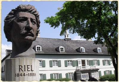
My last stop was St. Boniface Museum, which houses the largest collection of Riel related artifacts in Canada. I found this museum to be very informative and spent a good amount of time reading all the exhibit displays. There was a respectful silence throughout. It was a sobering exhibit, culminating with the man's personal items and remnants of the actual coffin used to transport his body from Regina to Winnipeg. The bust of Riel by noted Francophone artist Réal Bérard is located in front of the museum. Erected in the late 1980s, this depiction seems to exude steadfast calm and outward vision.


Once I was back home from my trip, I picked up Brown’s graphic novel again for another read: the narrative was all the richer because of my stay in Winnipeg. I now understood the significance of certain placenames: Fort Garry, the Wolseley neighbourhood where I had spent a lazy Sunday with a friend, the relevance of The Forks as the future site of the Canadian Museum of Human Rights. Thinking back upon my train journey and re-reading Riel's biography, I was reminded of the role the Canadian Pacific Railway played in transporting troops to counter the North-West rebellion of 1885 in what is now Saskatchewan. The Métis infinity symbol also took on added significance. I had made an assemblage more than ten years ago in the shape of a Figure 8 Traintrack to represent my double heritage as I have two intertwining families.


The Double Loop — Figure 8 Traintrack, 1998
Assemblage (3’7" x 6’ x 4’)
© Julie Lapalme
Photo by Sandra Belanger


It was only after that fact that I came across the Métis infinity symbol in Northern Ontario. I had noticed the shape while walking by the Sudbury Métis Council. It wasn't until recently that I learned that this symbol adorned a flag that was first used by Métis fighters in 1816 —  the oldest Canadian patriotic flag according to The Canadian Design Resource, a constantly expanding library of Canadian design and material culture.

“ This represents the coming together of two distinct and vibrant cultures, European and indigenous, to produce a distinctly new culture, the Métis. It symbolizes the creation of a new society with roots in both Aboriginal and European cultures and traditions. ”

I feel like I only skimmed the surface of Winnipeg on my short stay and want to return to delve further into its history. As a Franco-Ontarian, I understand the struggle of Franco-Manitobans to maintain the French language and culture in a sea of other languages and cultures. (The Manitoba Museum mentions a “plural Manitoba” made up of First Nations, Métis, French Canadians, British, Selkirk and Orkney Scots, Ukrainians, etc.) Since my return, I’ve been reading another of Gabrielle Roy's works — Fragiles lumières de la terre (1978). While this collection of non-fiction spans her entire career, I'm interested in her writing on immigrant communities in the prairies.

Sunday, May 30, 2010

Process: Macroblogging


Working with the Web everyday, I find I spend little time on Facebook on my off hours. I resist spending more time on the computer after work. Yet, if I really wanted to limit my screen time, why did I choose to blog?

It is of course a forum to express views and tell stories, a tool to communicate, to start a dialogue… We argued the potential of the blogging medium as a new writing tool in grad school. Its underlining structure, much like the journal, depends on chronological entries, of postings in time. While the discipline and rigor of writing regularly could only help improve one’s craft, the inherent qualities of the blog, like thematic cloud tags, interlinking and multimedia, could arguably provide new ways of writing, even stirring up new ways of thinking about the creative process itself. The format of the blog has adopted Deleuze and Guattari’s philosophical concept of the rhizome: multiple, in-between and non-hierarchical.

My own social networks (Facebook and LinkedIn) are indeed rhizomatic in that they are on the surface and widely spread out. The communication style is staccato-like and sporadic. Some would say concise, especially when referring to microblogging — the 140 characters that constrain the tweet. As an artist however, I am more interested in the opposite. Would it be macroblogging? The sometimes rambling but usually exploratory writing exercises that allow me to develop my ideas in depth. A tool to help me to reflect on various themes from placenames and personal mapping, to visual representations of time, memory and knowledge.

I also chose the blog for the documentation aspect, after the fact. That is, the postings can be mulled over and written anywhere and recorded later on line. I don't always subscribe to the myth of the mobile worker. I’ve found that trying to work on the train with my laptop is a trying exercise: not enough elbow room, bouncy, vibrating screen and frustratingly intermittent wireless connection. Better to jot down my notes on paper and re-transcribe later. We do not always have to be connected, working at breakneck speed and multitasking to death. I’ve become almost defiant about working offline at a slower pace. It is a delight to sit in a park with the breeze in my hair, to take the time to slow down, to reflect and write; to enjoy a coffee in a bustling café, where the murmurs and voices stir up thoughts and help shape their written form and cadence.

In this way, the blog has effectively freed me from the screen as reflective off line activity is just as much part of my process. Though I could update the blog remotely using RSS feeds and a handheld device, I chose the low-tech approach. I enjoy the messy capture of intrusive, spontaneous thoughts on whatever is at hand, collecting random scribblings on torn newspaper, napkins, VIA rail paper bags and beer coasters that I amass while on my various commutes – from the short stroll to the compost heap or grocery strore, to the long, dreamy metro rides home.

The piecemeal aspect of the blog also intrigued me in terms of my subject matter: pieced together notions of time and place, unreliable tidbits of memory, flashes of insight, parts of the whole. Responded to this description of time by Michel Serres and Bruno Latour (1995) cited in “Some new instructions for travelers: the geography of Bruno Latour and Michel Serres” by Nick Bingham and Nigel Thrift (Thinking Space, 2000):

time does not flow according to a line. … nor according to a plan but rather according to an extensive, complex mixture, as though it reflected stopping points, ruptures, deep wells, chimneys of thunderous acceleration (rendings, gaps) – all sown at random, at best in a viable disorder (284).

With Tongue Rug, the last line would read more like:

time is all sewn at random, at best in a viable disorder…

Friday, May 7, 2010

Process: Dead lake


The Turcot interchange is often on my mind these days as it is a daily topic in the news. I live only a couple of blocks away: ducking nervously under its towering structure when cycling, and passing by the yards during my Montreal-Ottawa commute. Upon entering and departing the downtown core by train, one is faced with an industrial landscape for the most part, which calls up Montreal’s industrial heritage and the South West's reputation as Canada’s “cradle of industrialization”. The Turcot yards appear like a desolate wasteland with mounds of cement scattered about, dusty barren fields and crumbling overpasses. No lake to be found.

Having grown up in Sudbury in the 70s, I have seen the results first hand of massive regreening efforts. Greater Sudbury's land reclamation project transformed what was once lauded as a moonscape, because of the exposed blackened bedrock ravaged by acid rain and unregulated logging, into an environmental success story. Near the downtown core is Ramsey lake —long considered a “dead lake’— which was part of this environmental reclamation project. On the east part of the lake is a scenic natural area with 950 hectares of protected green space. While the Lake Laurentian Conservation Area offers multi-usage trails for cyclists, skiers and snowshoers, I find the trail system lacking in that it is not fully integrated with a developed urban cycling infrastructure due in part to the rocky terrain of the Cambrian shield.

This is where the South-West of Montreal differs as the infrastructure already exists because of the Lachine canal. In fact, the Pôle des rapides area boasts 21 km of urban trails. The city has already invested 9.9 million dollars into Montreal's cycling trails and plans on creating another 50 km into the trail network this year alone for a total of 552 km (Métro, May 7). Each of the three Turcot reconstruction proposals include a network of cycling trails and for just cause. The current economic climate is leading some city planners to think in the short term and simply promulgate the car culture of the 60s with a straight-forward reconstruction of the aging interchange, when more thought needs to be given to the ecological footprint on the area and the quality of life of its citizens in the long term.

Indeed, the South West mayor, Benoit Dorais, sees the Turcot reconstruction as an opportunity to improve the economic development in the area. He affirms that there is not merely a need for assuring traffic flow through the South West with an improved road infrastructure, but a social and economic need to develop the area itself in conjunction with the modernization of its roadways. (La Voix Pop, André Desroches, May 27, 2010).

Web 2.0 has create a climate for lively exchange on this topic. The South West borough launched its own Facebook page in April, and not surprisingly the going ons of the Turcot reconstruction project appear front and centre. I can’t think of another topic that can benefit more from going viral these days. It’s not to say that this digital medium takes the place of local community papers like La Voix Pop. It is a complement to the weekly paper with its ability to provide links to related information, incorporate multimedia and leverage Web 2.0 tools to help build community.

There are two frontrunners in opposition to the Quebec Ministry of Transport’s reconstruction plan for the Turcot: Turcot 375 and the City of Montreal. Though the Turcot 375 plan to increase public transport and create a 75 hectares urban park at the foot of the Saint-Jacques escarpment seems promising, I admit to being a little underwhelmed by the video.


The City of Montreal’s plan won me over however with the construction of a new tramway linking downtown to Lachine and LaSalle, a new park to “preserve and enhance the Saint-Jacques escarpment” and a residential area which will “favour quality architecture, given the high visibility of both sites”. The artist rendering of Parc de la falaise presented a less abstract vision than the futuristic video. I can simply see myself living in this area: it brought it down to human scale — the pedestrian, the cyclist. Montreal 2025 successfully used the picturesque and the lure of green spaces as a strategy.

Montréal 2025

As an entry point into the city, the City of Montreal’s plan shapes that first impression of the cityscape. A major regreening effort paired with the Turcot reconstruction would invariably promote active communities by way of cycling and walking trails and encourage public transport. By its placement, it would also create a green corridor that links Atwater market to Lachine. Montreal often boasts of its green spaces in tourism brochures, but the reality is that the ratio of green spaces on the island is quite low. One just needs to look at satellite view in Google maps to see the small isolated parcels of green. Like with the Sudbury scenario, planting trees and protecting wetlands can not only help improve air and water quality it can lead to improved quality of life for its residents.

I can't speak with the authority of an urban planner or an environmentalist. I speak simply as a citizen with visions of what my neighbourhood and city could become. Knowing the history of the South West's own "dead lake"or ghost lake, could the city's proposed Parc de la falaise mean a re-appearance of the Lac aux loutres?

Wednesday, April 21, 2010

Progress: April 21, 2010


As part of the Metropolis Blue Student Literary Programme, I gave a presentation on literary blogs for l'antenne Communication-Jeunesse de l'école Antoine-de-Saint-Exupéry at the municipal library in Saint-Léonard. Over the course of our exploration, we talked about what sets a blog apart from a simple webpage. I emphasized the viral nature of the blog with its multitude of outward associative links. Also noted the facility in which you can classify, archive and navigate content using either intuitive key-words (tags) or the chronological ordering more akin to the journal format.

I briefly presented my Tongue Rug project and talked about how the blog/rug and posts/tongues act as a sort of memory device, a virtual archive. We discussed how the database capacities of blogging programs and other social media makes the Web the ideal tool for archiving. The City of Montreal has recently posted their archives on YouTube for instance (Les archives de Montréal plongent dans le web 2.0, Métro, April 6).


In this clip produced for the City of Montreal by Associated Screen News, we see a rather optimistic glimpse of the "modern city" in the late fifties: boxy cars in the streets, fruit and vegetables stands buzzing with people at the Marché Bonsecours and playgrounds teaming with energetic children on jungle bars. Woman in flouncy skirts and tramways in the streets. A window on another era.


CBC Digital Archives has had its own YouTube Channel since 2007. This CBC-TV clip about the ski-doo and its inventor, J. Armand Bombardier, brought back fond memories of winters at the cottage. My dad and my uncles would attach the toboggan to the back of the ski-doo, and on a few occasions, the old Ford. My cousins and I would pile on, holding on for dear life while they made sloppy donuts on the frozen expanses of Lac Panache.


Traditional museum displays take on another form via the web through interactive interfaces: Héritage Montréal's project — Memorable Montreal : Montréal en quartiers — features an interactive map of the Island with five off-circuits that are narrated with movie clips using archival photographs and videos: Little Italy, the Square Mile, Côte-des-Neiges, Dominion Square, La Fontaine Park and the Lachine Canal. Of particular interest to me was the section on all the bridges that span the St-Laurent, detailing the history, construction and protection actions of each structure. This site opened my eyes to the complexity of the structures that I have crossed many times on my bike: crossing the windy stretch of the Pont Champlain estacade or the Concordia Bridge, or cycling the vertiginous heights of the Jacques-Cartier will now be a richer experience knowing their varied histories.

The public can also participate in developing archival collections. La Société du Vieux-Port de Montréal is asking the general public for assistance in providing either old photographs or personal testimonials about everyday life in the Old Port of Montreal between the time period of 1930–1976 (Vieux-Port: À la recherche de son passé, Métro, April 21). On the Quais du Vieux-Port de Montréal website, you can learn more about the golden age of the Montreal port (1896–1930) by way of an interactive map with archival photos of Grain Elevator no 5, The Tugboat Daniel McAllister, the Refrigerated Warehouse and Hangar 16 among other historical points of interest.

In the past you had to book a visit in person to a library to conduct research. Though a visit is still an option, you can now access information in your own home as a free online resource. Just looking at the Bibliothèque et archives national du Québec and Library and Archives Canada web portals, it is apparent that never before has there been so much archival material at our disposal. These archives are an invaluable tool to understanding Montreal, a city in constant flux.

I wonder if this will result in renewed interest in local history and our shared heritage, especially if they are used as pedagogical tools with young people? The blog format itself has the potential to create unique collaborative projects, bringing individual and collective stories to the forefront.

An example of a successful collaborative site is Shorpy.com — the "100-year-old photo blog"— renowned for its archive made up of thousands of high-definition images spanning the 1850s to 1950s. The site's curious name is explained: Shorpy Higginbotham was a teenage coal miner who lived 100 years ago. Just browsing through the archive and reading the various comments from all over the world was a fascinating history course. I couldn't resist buying a reproduction of a photo of a Motor car, Canadian Government Colonization Co., Circa 1905. I particularly liked that the Shorpy archive can grow in an undetermined, open manner as members can share their own vintage photographs. It is an ongoing discussion and exchange on history, place and belonging.

Friday, April 2, 2010

Progress: April 2, 2010


Made a map with my own set of custom icons: the thirty three tongues that make up the Tongue Rug. Google Sladdakavring version II. The majority span Quebec with a few waypoints in Ontario, Alberta and Sweden. The map invites interaction, as it is only at a certain scale that you get a sense of the Tongue Rug.


View Tongues in a larger map


A new addition to the Google Maps application is the ability to drag a Street View icon to any street on the map to see a representation of the area in 360 degrees. There is currently a bug where the Street View Icon kills the zoom function.

Yet this new feature does not particularly help me with my project because my waypoints are more often than not in the middle of a field, a forested area or a remote trail. Also, I still prefer the patchwork, imperfect nature of my photos in the round and the room for human error: the possibility that I could be documenting the wrong body of water in my searches, the likelihood that I will get lost.

Sunday, March 28, 2010

Process: Green Ribbons


Went to a photo exhibition by André Denis entitled L’échangeur Turcot – Entre ciel et terre at la Maison de la culture Marie-Uguay. In an accompanying text, Jean Décarie described how the intertwining structure of the Turcot was seen as a work of art when it was inaugurated in the 60s — in time for Expo 67. He recalled how this autoroute was once seen as a symbol of progress in the “automobile age”, but had since become a symbol of pollution by today’s environmental standards. Despite its crumbling structure, this exaustive photo series of the Turcot clearly reveals a majestic sort of beauty and grandeur; what Décarie terms the “cathedral effect”.

In the artist statement, Denis writes:

“C’est une immense sculpture en béton dont le seul but est de maintenir en hauteur, comme s’il devait enjamber un lac invisible, le point de joinction de ces grands axes routiers montréalais.”

Indeed this “invisible lake” was called Lac aux Loutres, situated at a point where the Rivière Saint-Pierre once widened into wetlands. It made me think of an interesting article by André Desroches that I had read recently in La Voix Pop (Projet de création d'une trame verte, 25 mars 2010). He interviewed Patrick Asch, the director of Héritage Laurentien. Founded in the mid-nineties, this organization works at protecting and promoting natural areas in the Saint-Laurent valley, the South-West of Montreal in particular.

The article focused on the “Trame verte” project, which would help create green corridors in the South-West. For example, a green corridor could potentially link parc Angrigon to parc des Rapides, a migrating bird sanctuary. Another corridor could link to the “falaise Saint-Jacques” or to Meadowbrook at the junction of Saint-Pierre, Lachine and Montreal-West. Not only would these green “ribbons” allow migratory birds and fauna to move freely, the public could use alternative modes of transport with cycling, walking and snowshoeing trails.

Asch promoted the numerous benefits of a green corridor: the improvement in air quality; the reduction of the effect of urban heat islands; the absorption of greenhouse gases; and the creation of recreational and tourist attractions for South-West communities.


View larger map of the Trame verte du Grand Sud-Ouest


In Facebook (Une trame verte pour le grand sud-ouest de Montréal), there is a link to an article about the Bronx River Greenway. An inspiring success story in that community: there are plans underway in the South Bronx to build a recreational trail connecting a series of parks on the East River waterfront.

Closer to home, there is the Greenbelt: a 20,000-hectare expanse of land in Ottawa-Gatineau with an extensive trail system passing through wetlands, farmlands and forests. Having worked in Ottawa off and on for the last five years, I can appreciate the benefits of this unique green corridor. One summer when living in Westboro, I cycled 40 km a day using the Greenbelt to commute to Kanata. On an almost daily basis, I would see Canada geese, deer and other small animals near the cycling paths and adjoining fields. Though that daily commute obviously increased my fitness level, it also provided me with emotional well being — the needed time and space to unwind after a long day. As an asthma sufferer, it was also a relief to breathe in clean air, as the trail system diverted me from the stress and fumes of heavy traffic.

From this first hand experience, I do not need to be sold on the importance of the “Trame verte” project for Montrealers. The ongoing plans to replace the Turcot Interchange could benefit from projects such as the one put forward by Héritage Laurentien. Instead of focusing solely on the replacement of the Turcot structure itself, which would simply promulgate the car culture of the 60s, a more holistic approach is needed to take in consideration the wider implications of this new autoroute for the people living in the area and determine the ecological footprint. With a little bit of vision, this could prove to be a success story for Montreal “down the road”.